Archive Record
Images

Metadata
Catalog Number |
2021.021.0001 |
Object Name |
Placemat |
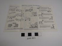
Scope & Content |
Tourist placemat listing points of interest in Natrona County with map: Fort Caspar Museum, Bessemer Bend, Speas Fish Hatchery, Cottonwood Beach Dinosaur Locality, Pathfinder Dam, Independence Rock, Devil's Gate, Mormon Handcart Visitor's Center, Emigrant Gap, Ryan (Prospect) Hill, Stone Ranch Stage Station, Hell's Half Acre, Teapot Rock, Salt Creek Oil Field, Richard's (Reshaw's) Bridge, and Edness Kimball Wilkins State Park with a listing of Natrona County Museums: Fort Caspar Museum, Nicolaysen Art Museum, Wyoming Adventure Science Center, Tate Earth Science Center and Mineralogical Museum, Werner Wildlife Museum, Casper Planetarium, Pathfinder Dam Interpretive Center, Richard's (Reshaw's) Bridge, Glenrock Palentological Museum, Crimson Dawn Museum, Midwest Museum, Mormon Handcart Visitor's Center, and Wyoming Game & Fist Department. Reverse side has games about dinosaurs and information about regional animals: rabbit, jackeroo, prairie dogs, ground squirrel, white-tail deer, mule deer, pronghorn, and wapiti. Put together by the Natrona County Historic Preservation Commission, the Natrona County Commissioners, the Casper Area Chamber of Commerce, and the Natrona County Lodging Tax Board. Drawn by Russell J. Hawley. |
Date Range from |
2000 |
Date Range to |
2009 |
Title |
Natrona County Residents, Then ... and Now; Natrona County, Wyoming Points of Interest |
People |
Hawley, Russell |
Search Terms |
Casper, Wyoming Natrona County Fort Caspar Dinosaur Animal Map Natrona County Commissioners Casper Area Chamber of Commerce |