Archive Record
Images
Metadata
Catalog Number |
2017.023.0030 |
Object Name |
Brochure |
Scope & Content |
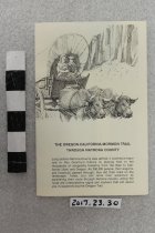
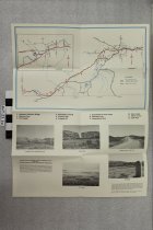
Multi-fold map, photos, and text of historic sites along the trails corridor through Natrona County. There is a larger map of county with an inset for the Casper area. Sites listed include: Richard's (Reshaw) Bridge, Mormon Ferry, Fort Caspar, Red Buttes Crossing, Emigrant Gap, Prospect Hill, Greasewood on Horse Creek, Steamboat Lake, Independence Rock, Devil's Gate, Martin's Cove, Split Rock. |
Date Range from |
1995 |
Date Range to |
2000 |
Title |
Oregon-California-Mormon Trail Through Natrona County |
Search Terms |
Natrona County Trail Historical Marker Emigrant Trails Devil's Gate Martin's Cove Fort Caspar Mormon Ferry Reshaw Bridge |