Search Term Record
Metadata
Name |
Fort |
Related Records
-
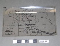
1988.048.0001.B - Map
Map of "Forts and Trails on the Northern Plains, 1866-1868." 1 mylar transparency and 1 paper print copy.
Record Type: Archive
-
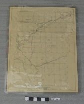
1997.036.0001 - Map
Maps of Emigrant Trails and surrounding areas. All copyright Wyoming State Archives, 1959. Scale 1" = 4 miles. Maps of: Fort Sanders; Fort Russell; Lander's Cut-Off -- both east and west sections; Parting of the Ways; and Fort Caspar/Independence Rock/South Pass.
Record Type: Archive
-
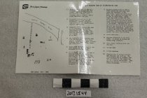
2017.015.0044 - Brochure
Laminated black & white brochure from Fort Caspar Museum with map and text, "Self Guiding Tour of Reconstructed Fort". Folded in half, 1985.
Record Type: Archive
-
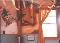
3502 - Print, Photographic
Murals on the wall of the Enlisted Mens Service Club at Casper Army Air Base, winter handcart and riding into fort scenes, 1991. Horizontal Color.
Record Type: Photo
-
3548 - Print, Photographic
Gas barbecue cooker being built at Casper College, with Eilene Bookhout and Zula Safford, Fort Caspar Museum Association Board Members, inspecting the cooker, 1991. Horizontal Color.
Record Type: Photo