Search Term Record
Metadata
Name |
Emigrant Trails |
Related Records
-
2006.019.0001 - Videotape
VHS Videotape. "Trails West" by the US Department of the Interior, Bureau of Land Management. In white cardboard VHS box. Deals with the emigrant trails across the west.
Record Type: Archive

-
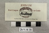
2017.015.0031 - Brochure
Tri-fold, cream colored brochure "Join Us! / Fort Caspar to Cody" and a logo for the Wyoming Centennial Wagon Train along the Bridger Trail. Contents explain the June 2 - July 2, 1990 trip by wagon along the trail.
Record Type: Archive
-
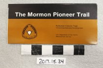
2017.015.0034 - Brochure
Black and tan fold out brochure, "The Mormon Pioneer Trail", published by the National Park Service, 1987. Contents include photographs, map, and general information about the trail.
Record Type: Archive
-
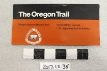
2017.015.0035 - Brochure
Black and tan cover fold out brochure, "The Oregon Trail". Published by the National Park Service, 1987. Contents include photos, map, and general information about the trail.
Record Type: Archive
-
2017.015.0036 - Brochure
Photocopy tri-fold brochure on yellow paper, "Mormon Ferry / at the / Upper Crossing of the / North Platte". Image on front is Harold Hopkins painting of the ferry crossing and contains text about history of the ferry and the upper crossing. "Distributed by the Mormon Ferry Restoration, INC".
Record Type: Archive
-
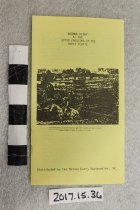
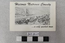
2017.023.0029 - Brochure
Multi-folded brochure featuring a map and text for historic sites in Natrona County. The cover has a drawing of immigration at Devil's Gate and states it is a Self Guided Tour". Unfolded, there are 19 historic sites listed on a map of Natrona County and text about each site to include: Bessemer Bend, Emigrant Gap, Rock Avenue, Prospect Hill, Devil's Gate, Independence Rock, Pathfinder Dam, Teapot Rock, Salt Creek, Midwest Electric Plant, Joshu...
Record Type: Archive
-
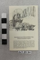
2017.023.0030 - Brochure
Multi-fold map, photos, and text of historic sites along the trails corridor through Natrona County. There is a larger map of county with an inset for the Casper area. Sites listed include: Richard's (Reshaw) Bridge, Mormon Ferry, Fort Caspar, Red Buttes Crossing, Emigrant Gap, Prospect Hill, Greasewood on Horse Creek, Steamboat Lake, Independence Rock, Devil's Gate, Martin's Cove, Split Rock.
Record Type: Archive